Lesson 1 of 6
Begin with a birth.
Imagine stepping outside at the moment someone is born and looking up at the sky. What you can see depends on where you are standing, but the chart we are about to build will also include the directions hidden below your horizon.
A natal chart gathers the sky around a birth onto one page. To build one, we begin with a birth record rather than a drawing: we need to establish when the birth happened and where on Earth it took place. As we work through those details, we’ll see why the time and the place each contribute something to the finished chart.
Meet Mira.
Imagine Mira was born in London on 1 January 2000, at 12:00 Coordinated Universal Time, usually shortened to UTC. We’ll explain that time reference in a moment. For her birthplace, we’ll use the rounded location 51.5° north, 0.12° west. Mira is fictional, and these details give us a consistent example to follow as her chart takes shape over the six lessons.
You can stay with Mira throughout, or use your own birth details in the exercise below. We’ll prepare her record first so you can follow the reasoning before applying it to another birth.
Find the moment behind the clock reading.
Mira’s record gives us a date and a time, but a clock reading alone would leave something unresolved. Think of two people speaking on the telephone across the world: it may be evening for one and morning for the other, even though their conversation is happening at the same moment. To identify a birth moment from a local clock reading, we therefore need to know which time zone that clock was following.
UTC gives us a common reference for expressing that moment. Mira’s time is already recorded in UTC, so we can carry it forward directly. If another birth record gives local time instead, we need to convert its date and time to UTC before using it in the exercise.
Suppose a birth is recorded at 14:30 in a place where the local clock is two hours ahead of UTC. The local clock reads two hours later than the UTC clock, so subtracting those two hours gives 12:30 UTC. We have expressed the same birth moment using a different clock reference.
14:30 − 2 hours = 12:30 UTC
If the subtraction crosses midnight, the date changes with it. A birth at 01:30 on 2 January, where local time is UTC+2, becomes 23:30 UTC on 1 January.
For your own birth record, use the offset that applied at the birthplace on the birth date, including daylight saving time where relevant. It may differ from the offset used there today. The National Institute of Standards and Technology’s guide to local time explains how local clock readings relate to UTC.
When the local clock differs from UTC, the conversion needs to change the clock reading as well as its label: writing “UTC” beside an unchanged local time would identify a different moment. If you don’t yet know your own birth time in UTC, you can follow Mira’s record while you learn how the chart is built.
Behind the clock: why UTC began with radio signals
Long before we could check the time on a phone, radio broadcasts carried time signals to distant listeners. For a navigator finding a ship’s position from the stars, a dependable time reference was essential: the calculation needed to account for how far Earth had turned. Time signals from different countries therefore needed to agree.
On 1 January 1960, the United States and the United Kingdom began coordinating their time and frequency transmissions, with the United States Naval Observatory and the Royal Greenwich Observatory leading the effort. Other institutions and countries joined. That coordination became the foundation of Coordinated Universal Time.
Atomic clocks offered a steadier measure of seconds than Earth’s slightly irregular rotation, but navigators still needed a connection to the turning Earth. In 1972, UTC adopted atomic seconds with occasional one-second adjustments, called leap seconds, to keep that connection. Its early purpose was to provide consistent broadcast time signals that could serve precise timekeeping and celestial navigation together. For Mira’s chart, we use UTC as the shared reference for her birth moment.
UTC’s origins · International Telecommunication Union, sections 2.1 and 3.1.6
Locate Mira’s birthplace.
We now have Mira’s birth moment. To place her in London, we also need a way to describe where London lies on Earth. A city name is useful to us, but the calculation needs a more precise location. We’ll describe it by measuring angles from two reference lines, one for north and south and the other for east and west.
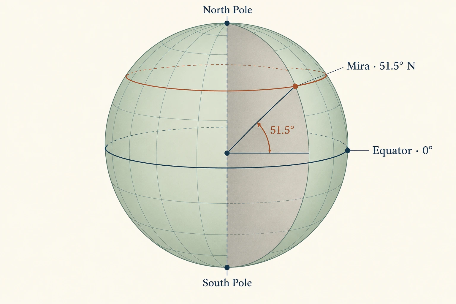
Start with the equator, the line that circles Earth halfway between the poles. Mira’s birthplace lies 51.5° north of it; that angle is her latitude. The equator has latitude 0°, with north measured as positive and south as negative. We therefore enter Mira’s latitude as +51.5. The scale reaches +90° at the North Pole and −90° at the South Pole.
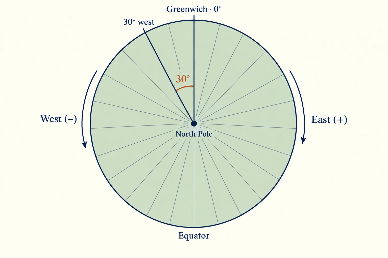
Latitude tells us how far north or south to go, but we still need to locate Mira east or west. For that second angle, we use a reference line running from pole to pole through Greenwich. A line of this kind is called a meridian, and the angle measured east or west from the reference meridian is longitude. Mira’s birthplace is 0.12° west of Greenwich, so her longitude is −0.12: west is negative and east is positive, up to 180° in either direction.
Together, +51.5 and −0.12 describe the rounded location we’ll use for Mira. The signs carry the directions, so we keep them when entering the numbers. If you look up your own birthplace on a map, use decimal degrees and enter latitude first, longitude second. These angles describe a place on Earth; in the next lesson we’ll begin measuring directions in the sky.
Behind the reference lines: a small observatory at Greenwich
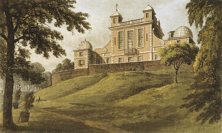

In 1675, John Flamsteed became the first Astronomer Royal, charged with mapping the heavens accurately enough to help navigation. Greenwich’s grand Octagon Room offered broad windows onto the sky. But its walls were not aligned with a meridian, making it poorly suited to precise positional observations. Much of that work happened in a small building in the garden instead.
For measuring the sky, a dependable reference direction mattered more than an impressive view. We need that same habit: attach every position to a reference.
Why the chart needs both.
Imagine another birth happening at exactly the same moment as Mira’s, in a different city. For the main planetary positions, Astrology Engine uses Earth’s centre as its viewpoint, so those positions would be the same for both births. The view from each birthplace, however, can differ: the horizon belongs to the place where we are standing.
This is why Mira’s chart needs her location as well as her birth time. The time identifies the moment for which we calculate the planetary positions, while the time and place together let us relate those positions to her local sky. Later lessons will develop that local view and show how it contributes to the chart.
For now, we have prepared what we need to begin: Mira’s birth moment is 12:00 UTC on 1 January 2000, and her rounded birthplace is +51.5° latitude, −0.12° longitude. In the exercise below, you can carry those details forward or enter your own record using the same conventions.
Your turn
Choose your moment.
Use your own birth details, or follow Mira. Enter the date and time in UTC, including any change of date when converting from local time.
2000-01-01 at 12:00 UTC · 51.5° latitude, -0.12° longitude
Saved birth details stay in this browser when you reload or return. Use Mira’s example to clear your saved record. No birth details are sent anywhere. Planet calculations arrive in a later lesson.
Make it yours
Try the idea.
A few questions to put the pieces together. Take your time; you can try again.
Begin turning the sky into a chart.
With Mira’s moment and place established, we can begin learning how to represent her sky on a page. The next lesson introduces the circle on which we’ll place the planets, showing how a direction such as 47° becomes a position we can read on a zodiac wheel.